

 EN
It has been included in the government work report for three consecutive years, with its positioning upgraded from "new growth engine" and "emerging industry" to "emerging pillar industry". The national "15th Five-Year Plan" clearly states that a modern low-altitude economic system will be established by 2030, with a market size targeting 3.5 trillion yuan. The top-level design has been set, and the direction is clear. Beijing, Shanghai, Guangzhou, and Shenzhen are competing to make layouts, and provincial capitals are also joining in. This is a top-down industrial wave.
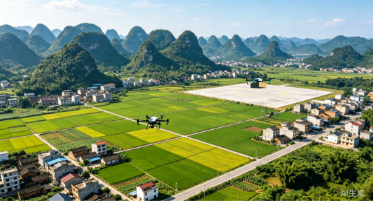
If we talk about the first half of low altitude economy, look at big cities; In the second half, it depends on the county.
In the first half, it was about policy breaking, technological verification, and demonstration in big cities. In the second half, the low altitude economy is taking root in the county town, reshaping the spatial dimension of county-level economic development.
This is not simply a market downturn, but rather a sign that a new economic form is taking shape - the 'county-level low altitude economy'.
The economic form formed by the county as the basic unit, relying on airspace resources, and driven by grassroots governance and characteristic industries, with independent development logic and unique value system, has become a new driving force for regional economic development.
Why is it a county
The inevitable choice for the development of low altitude economy
China has 2843 county-level administrative regions, accounting for over 90% of its land area and carrying more than half of the country's permanent population.
From the perspective of application scenarios, counties are the most real demand side for low altitude economy. The "last mile" of low altitude logistics, the activation and utilization of low altitude cultural and tourism resources, and the rapid response to low altitude emergencies, which are the three key scenarios clearly defined by the country, are almost all deeply bound to counties. Agricultural counties require plant protection inspections, tourist counties require low altitude sightseeing, and industrial counties require park monitoring - this "tailored to local conditions" landing path is highly consistent with General Secretary Xi Jinping's emphasis on "developing distinctive county-level economies". It's not about using a template to cover everything, but about making low altitude technology serve the personalized needs of different counties.
From the perspective of spatial resources, counties are the widest testing ground for low altitude economy, and the relatively relaxed airspace conditions provide valuable space for the normal operation of low altitude economy, which is an inherent advantage that big cities find difficult to replicate.
From the perspective of strategic layout, counties have been identified as key carriers for the large-scale development of low altitude economy. More and more counties are incorporating low altitude economy into their development plans and planning industrial parks, and counties need new growth points.
Low altitude economy also requires county-level markets. To truly form a low altitude economy with a scale of 3.5 trillion yuan, it is far from enough to rely on the demonstration of a few big cities, and it must be spread in vast counties. This is the law of industry and also a practical choice.
A new economic form is emerging: county-level low altitude economy, which is not only a new driving force for high-quality development of counties, but also the main battlefield for the large-scale landing of low altitude economy.
Zhongke Cloud Map
Pioneer of Low altitude Economy in County Areas
The company called Zhongke Yuntu was the first to push the concept of "county-level low altitude economy" into practice.
Zhongke Yuntu, incubated and invested by Guangdong Academy of Sciences, is a national level specialized and innovative key "little giant" enterprise, a core achievement transformation unit of the national "13th Five Year Plan" key research and development plan, and a project undertaking unit of the "14th Five Year Plan" key research and development plan. It independently constructs three core systems of low altitude remote sensing network, low altitude route network, and low altitude large model, and creates a low altitude data intelligence base to provide fully automatic, high-frequency, and high-precision air monitoring and intelligent services for energy inspection, smart cities, ecological environmental protection, emergency security, logistics and manned transportation fields. It is a leading enterprise in the field of low altitude economy.
Starting from power inspection, Zhongke Cloud Atlas has transformed low altitude remote sensing technology into mature products, occupying the first place in the market in the field of unmanned aerial vehicle automation inspection of power grids. Subsequently, the product technology will gradually be implemented in smart cities, serving multiple fields such as urban management, water management, environmental protection, transportation, and emergency response.
In 2020, Zhongke Yuntu launched the first pilot project of a low altitude unmanned aerial vehicle remote sensing network for smart cities in Danzao Town, Nanhai District, Foshan City. In 2022, the integrated social governance system of air, space, and earth will be promoted to the entire Nanhai district. The project covers 10 departments and 41 business scenarios, sorts out 85 law enforcement and certification matters, and promotes the issuance of the country's first administrative law enforcement guidance for unmanned aerial vehicles. It has solved the problem of "small horses pulling big carts" for complex urban and rural governance in Nanhai, managing a population of over 4 million, over 500000 rural homesteads, and over 730000 market entities.
This is a successful 'project' - the technology has been validated and the pattern has been successfully implemented. But Zhongke Cloud Atlas did not stay in the mindset of "doing projects". The founding team sees a broader picture: in the future, when the low altitude economy spreads in more regions of China, what Zhongke Yuntu needs to do is to provide the most solid "cornerstone" for each county, not to deliver a project, but to cultivate a new model that can grow on its own and resonate with regional development.
In the view of Pan Yifeng, President of Zhongke Cloud Atlas Group, the development of low altitude airspace will profoundly change the existing pattern of human life and economic development, reconstruct urban spatial resources and regional economic patterns. And the county is the widest testing ground for this transformation. Zhongke Yuntu has chosen to take root in it and become a steadfast pioneer and co builder in this transformation.
In May 2024, Zhongke Yuntu, together with other units, released the "Double Hundred District and County Plan" and the first 2 billion yuan low altitude infrastructure construction fund in China. Together with the hundred districts and counties, they will complete the construction of low altitude infrastructure such as the low altitude sky road network and low altitude remote sensing network, providing capital support for county layout.
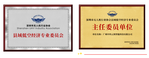
In January 2026, the first county-level low altitude economy professional committee in China, the Shenzhen UAV Industry Association County Low altitude Economy Professional Committee, was established, with Zhongke Yuntu as the chairman unit, promoting the exploration of county-level low altitude economy from "fighting independently" to "rule co construction", and building the first industry platform for county-level low altitude economy to move from "pilot demonstration" to "systematic promotion".
If we talk about the first half of low altitude economy, look at big cities; In the second half, it depends on the county.
In the first half, it was about policy breaking, technological verification, and demonstration in big cities. In the second half, the low altitude economy is taking root in the county town, reshaping the spatial dimension of county-level economic development.
This is not simply a market downturn, but rather a sign that a new economic form is taking shape - the 'county-level low altitude economy'.
The economic form formed by the county as the basic unit, relying on airspace resources, and driven by grassroots governance and characteristic industries, with independent development logic and unique value system, has become a new driving force for regional economic development.
Why is it a county
The inevitable choice for the development of low altitude economy
China has 2843 county-level administrative regions, accounting for over 90% of its land area and carrying more than half of the country's permanent population.
From the perspective of application scenarios, counties are the most real demand side for low altitude economy. The "last mile" of low altitude logistics, the activation and utilization of low altitude cultural and tourism resources, and the rapid response to low altitude emergencies, which are the three key scenarios clearly defined by the country, are almost all deeply bound to counties. Agricultural counties require plant protection inspections, tourist counties require low altitude sightseeing, and industrial counties require park monitoring - this "tailored to local conditions" landing path is highly consistent with General Secretary Xi Jinping's emphasis on "developing distinctive county-level economies". It's not about using a template to cover everything, but about making low altitude technology serve the personalized needs of different counties.
From the perspective of spatial resources, counties are the widest testing ground for low altitude economy, and the relatively relaxed airspace conditions provide valuable space for the normal operation of low altitude economy, which is an inherent advantage that big cities find difficult to replicate.
From the perspective of strategic layout, counties have been identified as key carriers for the large-scale development of low altitude economy. More and more counties are incorporating low altitude economy into their development plans and planning industrial parks, and counties need new growth points.
Low altitude economy also requires county-level markets. To truly form a low altitude economy with a scale of 3.5 trillion yuan, it is far from enough to rely on the demonstration of a few big cities, and it must be spread in vast counties. This is the law of industry and also a practical choice.
A new economic form is emerging: county-level low altitude economy, which is not only a new driving force for high-quality development of counties, but also the main battlefield for the large-scale landing of low altitude economy.
Zhongke Cloud Map
Pioneer of Low altitude Economy in County Areas
The company called Zhongke Yuntu was the first to push the concept of "county-level low altitude economy" into practice.
Zhongke Yuntu, incubated and invested by Guangdong Academy of Sciences, is a national level specialized and innovative key "little giant" enterprise, a core achievement transformation unit of the national "13th Five Year Plan" key research and development plan, and a project undertaking unit of the "14th Five Year Plan" key research and development plan. It independently constructs three core systems of low altitude remote sensing network, low altitude route network, and low altitude large model, and creates a low altitude data intelligence base to provide fully automatic, high-frequency, and high-precision air monitoring and intelligent services for energy inspection, smart cities, ecological environmental protection, emergency security, logistics and manned transportation fields. It is a leading enterprise in the field of low altitude economy.
Starting from power inspection, Zhongke Cloud Atlas has transformed low altitude remote sensing technology into mature products, occupying the first place in the market in the field of unmanned aerial vehicle automation inspection of power grids. Subsequently, the product technology will gradually be implemented in smart cities, serving multiple fields such as urban management, water management, environmental protection, transportation, and emergency response.
In 2020, Zhongke Yuntu launched the first pilot project of a low altitude unmanned aerial vehicle remote sensing network for smart cities in Danzao Town, Nanhai District, Foshan City. In 2022, the integrated social governance system of air, space, and earth will be promoted to the entire Nanhai district. The project covers 10 departments and 41 business scenarios, sorts out 85 law enforcement and certification matters, and promotes the issuance of the country's first administrative law enforcement guidance for unmanned aerial vehicles. It has solved the problem of "small horses pulling big carts" for complex urban and rural governance in Nanhai, managing a population of over 4 million, over 500000 rural homesteads, and over 730000 market entities.
This is a successful 'project' - the technology has been validated and the pattern has been successfully implemented. But Zhongke Cloud Atlas did not stay in the mindset of "doing projects". The founding team sees a broader picture: in the future, when the low altitude economy spreads in more regions of China, what Zhongke Yuntu needs to do is to provide the most solid "cornerstone" for each county, not to deliver a project, but to cultivate a new model that can grow on its own and resonate with regional development.
How to build low altitude economy in counties
Hukou sample becomes a national benchmark
Unlike traditional smart city projects that are "done and left", Zhongke Yuntu adopts a "rooted and not left" model in the county: keeping profits in the county, keeping talents in the county, participating in regional planning, and contributing to the development of low altitude economy in the entire region.
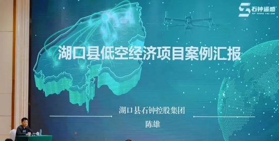
In May 2023, at the confluence of the Yangtze River and Poyang Lake in Hukou, Jiangxi. This county town, which has a 24 kilometer long river coastline and a 30 kilometer Poyang Lake coastline, has reached a strategic cooperation with Zhongke Yuntu.
At that time, the low altitude economy in the county was still a 'no man's land'. We are not here to do a project, but to explore and cultivate a county-level low altitude economy sample together with Hukou, so that the low altitude economy can truly take root locally, "recalled Pan Yifeng, President of Zhongke Yuntu.
In just one year, it has been proven that county-level low altitude economy is not a concept of "burning money", but a business that can self generate.
18 unmanned aerial vehicle intelligent base stations cover the entire area, reducing time and manpower investment by more than 90%. The project serves multiple departments including water conservancy, agriculture and rural areas, public security, emergency response, urban management, and environmental protection. With investment and capital recovery in the same year, it achieved a revenue of 12.93 million yuan and a profit ROI of over 60%.
But the value of Hukou is far more than that.
Firstly, it has paved a new path for the transformation of local state-owned enterprises. For Hukou state-owned enterprise Shizhong Holdings Group, this cooperation is not a simple equipment procurement, but a key outcome of the company's strategic transformation. Not only did it achieve excellent business performance in terms of investment and capital recovery that year, but it also found a new point of strength in the wave of transformation of urban investment companies. At the 2023-2024 Information Work Conference of Jiangxi Provincial Urban Investment Association, Hukou County shared as the only low altitude economy case, providing a vivid example of "coming from the wind and rain to the forefront of transformation" for 45 urban investment companies in the province.
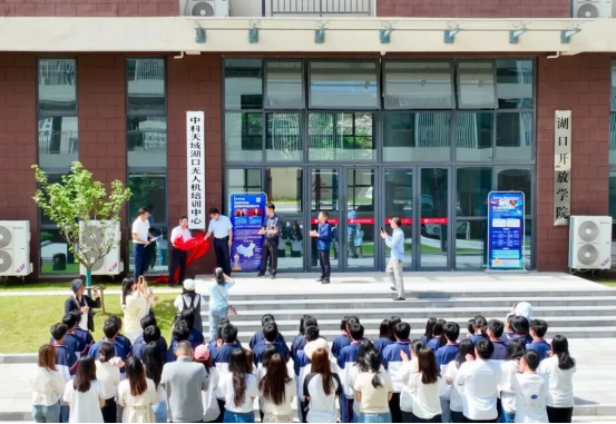
Hukou drone training center launched
Thirdly, a systematic layout of low altitude infrastructure has been completed. In December 2024, Hukou released the "Low altitude Sky Route" plan, taking the lead in completing the scientific layout of the low altitude public air route network. Liao Xiaohan, Director of the Key Laboratory of Low altitude Geographic Information and Air Route of the Civil Aviation Administration of China, commented, "Just as' building roads is the first step to getting rich ', the construction of low altitude sky roads is equally important. This network system will enable Hukou's low altitude economy to move from' being able to fly 'to' flying in an orderly manner '.
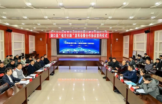
Hukou County held a press conference on "Low altitude Sky Road"
From 'One Point' to 'One Net'
Make low altitude economy a true productive force
The value of Hukou is not limited to just Hukou. This model of "infrastructure bottoming out, public services leading, commercial scenario monetization, and industrial ecological agglomeration" is being increasingly validated by more and more counties. From Jiangxi to Xinjiang, from Liaoning to Guangdong, the footprint of Zhongke Yuntu has spread to more than 100 regions across the country.
In Meishan, Sichuan, a low altitude economic development path of "city level coordination, county-level pilot, and city wide promotion" has been explored locally. In July 2025, Meishan Minjiang Industrial Investment Group and Zhongke Yuntu jointly established Zhongke Qingyun, which will coordinate the construction of a city wide low altitude remote sensing network through a municipal platform, and select Qingshen County as the first pilot. In its first year of operation, it achieved profitability and successfully undertook a 5.62 million yuan inspection service project, quickly verifying the feasibility of the model and attracting research teams from dozens of provinces and cities across the country, providing a replicable practical example for the development of low altitude economy at the municipal level.
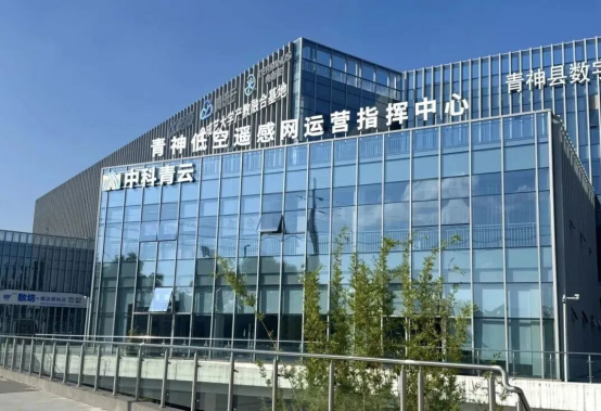
Hukou County held a press conference on "Low altitude Sky Road"
In Tianjin, a market-oriented sample of transitioning from infrastructure investment to technology service output is emerging. In April 2025, Zhongke Cloud Atlas reached a cooperation agreement with Tianjin Low altitude Economy Company. In June, a low altitude remote sensing network in Tianjin was established, creating the first national model of graded response application scenarios. And through market-oriented methods, we will coordinate services and provide low altitude remote sensing services for the entire region, transforming from infrastructure investment to technology output, and using our technical capabilities to undertake vertical industry businesses such as Tianjin Expressway and Jinghai Smart Park, forming a sustainable market-oriented operation model.
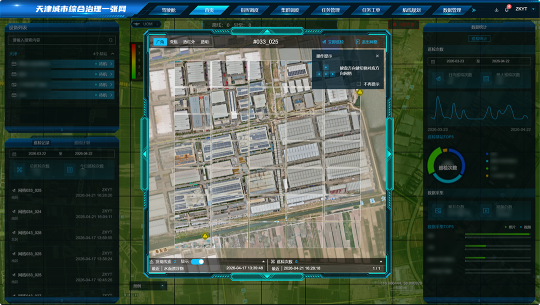
"County low altitude economy" is not a copy of a single model, but a creation based on local conditions. Large agricultural counties, strong industrial counties, famous tourist counties, and resource depleted cities - counties with different endowments are forging their own distinctive low altitude economic paths.
Different counties are connecting into a network, forming a constantly evolving and growing industrial ecosystem.
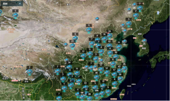
Meanwhile, this network is expanding outward. From a county to a neighboring county, from a county to a city, from a city to a province - this network not only serves the local area, but also forms route connections, data sharing, and emergency linkage with surrounding areas, gradually weaving into a cross regional low altitude service network, providing greater possibilities: cross county logistics routes, regional emergency linkage networks, larger scale data sharing and value mining
Standing at the beginning of the 15th Five Year Plan, the development of the low altitude economy has become increasingly clear. When technology stays in the local area, talent takes root, and industries form a closed loop, the low altitude economy is no longer just a concept, but a tangible productivity.
Now, 'creating a new form of low altitude economy in the county' is not just a concept, but also a new approach to the development of low altitude economy.